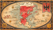
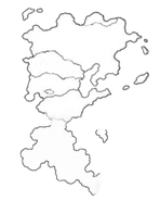
All known locations mentioned in Frieren: Beyond Journey's End. The locations are listed in the order they appear in the manga.
World Map
Gallery
Central Lands
- Royal Capital
- Holy City of Strahl
- Heiter's House
- Turk Region
- Warm
- Größe Forest
- Granz Channel
- Bredt Region
- Voll Basin
- Wille Region
- Riegel Canyon
- Waal, fortress city
- Klee Region
Northern Lands
- Eng Road (Locality)
- Graf Granat's Domain
- Decke Region
- Schwer Mountains
- Village of the Sword
- Appetit Region
- Alt Woods
- Raad Region
- Bande Woods
- Laub Hills
- Vorig, fortress city
- Klar Region
- Rohr Road
- Offen Mountain Range
- Kühl Region
- Saum Marshes
- Great Sanft Forest
- Fabel Village
- Graf Dach's Domain
- Etwas Mountains
- Heiß, fortified city
- Nachricht Region
Northern Plateau
- Bier Region
- Norm Company Territory
- Rufen Region
- Drachen Region
- Lake Korridor
- Great Tor Canyon
- Schmal Snowfield
- Weise Region
- Weise, fortress city
- Ernst Region
- Wissen Mountains
- Kino Pass
Imperial Territory
- Bohne Village
- Farbe Region
- Titan Fortress Ruins
- Hören Region
- Aufgabe Federation
- Eiseberg, the Imperial Capital
- Lorbeer Domain
- Kasten
Ende
Southern Lands
Trivia
- Seiko Yoshioka, one of the concept artists for the anime, illustrated some of the maps. To mimic the style of hand-drawn parchment maps, textured paper and ink were used.[2]
- "Klee" is German for "clover."
Notes
References
- ↑ 1.0 1.1 Frieren: Beyond Journey's End Anime: Episode 25.
- ↑ Seiko Yoshioka's Twitter: Frieren: Beyond Journey's End anime map design.


